Elevation vs Elevation Gain
Elevation is the distance above mean sea level. Elevation gain is how much elevation a person accumulates on a given route. This example route has three hills, each of which is 100’ tall:

Each of the summits’ elevation is 100’. But a hiker who climbs all three will gain 100’ three times — a cumulative gain of 300’ like this.

Just because a trail starts high doesn’t mean it will climb high. Below, the trailhead for trail A is about 600’ up, but only gains about 100’. That’s low elevation gain compared to trail B, which starts and ends closer to sea level, but climbs almost 400’.

Using this site’s charts
Routes on this site have charts that show their elevation gain and mileage. To help you compare, each chart also has two standard routes, our Cerro San Luis loop and Johnson Ranch, in gray.
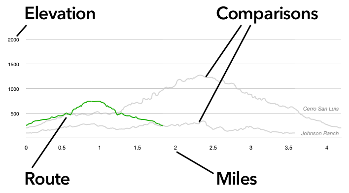
Above, Islay Hill (in green) is shorter than both Cerro San Luis and Johnson Ranch. Its elevation gain puts it between the two.
Choosing a Hike
We’ve found that most people are more capable than they think, and the best way to find what’s enjoyable is to join a hike and find out. We generally classify hikes as:
Beginner
1–5 miles, average grade about 5%. Mostly even terrain that’s more “tame” than “trail.” Not wheelchair accessible, but close, with well-defined edges and no serious obstacles to block the way.
Best for: People who walk around the block regularly and want to do more.
Examples: Johnson Ranch, the bluffs at Montaña de Oro State Park, Bob Jones without the Sycamore trail.
Casual
1–5 miles, average grade around 5–15% with some short parts as steep as 30%. Some uneven terrain will make you glad for good tread on your hiking shoes. Obstacles, like creek crossings or rock outcrops, are more like features than stumbling blocks.
Best for: People looking for an energetic walk where the challenge comes from a brisk pace more than going uphill … but uphill is a factor. You might get winded after climbing several hundred feet, but you recover and keep going.
Examples: Islay Hill, Spring-to-Spring at Pismo Preserve, Johnson Ranch at a brisk pace.
Intermediate/moderate
3–7 miles, average grade about 5–15% with some parts as steep as 40%. Expect some uneven terrain and several good hills. Some obstacles like creek crossings (dry or wet), boulders, trees.
Best for: For people who enjoy leaving paved surfaces behind a few times per month. You know the exercise and views are worth the sweat and trail dust. When climbing a thousand feet, you might get winded, but not discouraged.
Examples: Discovery Trail at Pismo Preserve, the 5-mile Cerro San Luis loop.
Challenging
5–20 miles or more. Average grade is 10–25% or more. Even the switchbacks are steep, and going downhill may require trekking poles. Obstacles are part of the fun.
Best for: You look forward to walking several hours with steep inclines. When someone says “let’s hike Bishop Peak,” you say, “that’s a fun warmup.” Others see that glint in your eye as you scan the horizon, notice the wear on your hiking gear, and assume you’re in charge.
Examples: Reservoir Canyon loop, Bishop Peak summit trail, Oats Peak/Valencia Peak loop at Montana de Oro State Park.